

By using this site, you agree to the Privacy Policy and Terms of Use.
Accept
India Times NowIndia Times NowIndia Times Now
Notification Show More
Font ResizerAa
  • Bharat Shreshtha Ratna Sanman
  • India News
  • Categories
    • Technology
    • Entertainment
    • The Escapist
    • Insider
    • Finance ₹
    • India News
    • Science
    • Health
Reading: NISAR satellite sends first radar images of Earth’s surface
Share
India Times NowIndia Times Now
Font ResizerAa
  • Bharat Shreshtha Ratna Sanman
  • India News
  • Categories
Search
  • Bharat Shreshtha Ratna Sanman
  • India News
  • Categories
    • Technology
    • Entertainment
    • The Escapist
    • Insider
    • Finance ₹
    • India News
    • Science
    • Health
Have an existing account? Sign In
Follow US

Home » NISAR satellite sends first radar images of Earth’s surface

India News

NISAR satellite sends first radar images of Earth’s surface

India Times Now Desk
Last updated: September 26, 2025 6:32 pm
India Times Now Desk
Published: September 26, 2025
Share
SHARE


Contents
  • Fruits of collaboration
  • Gain and loss of forests
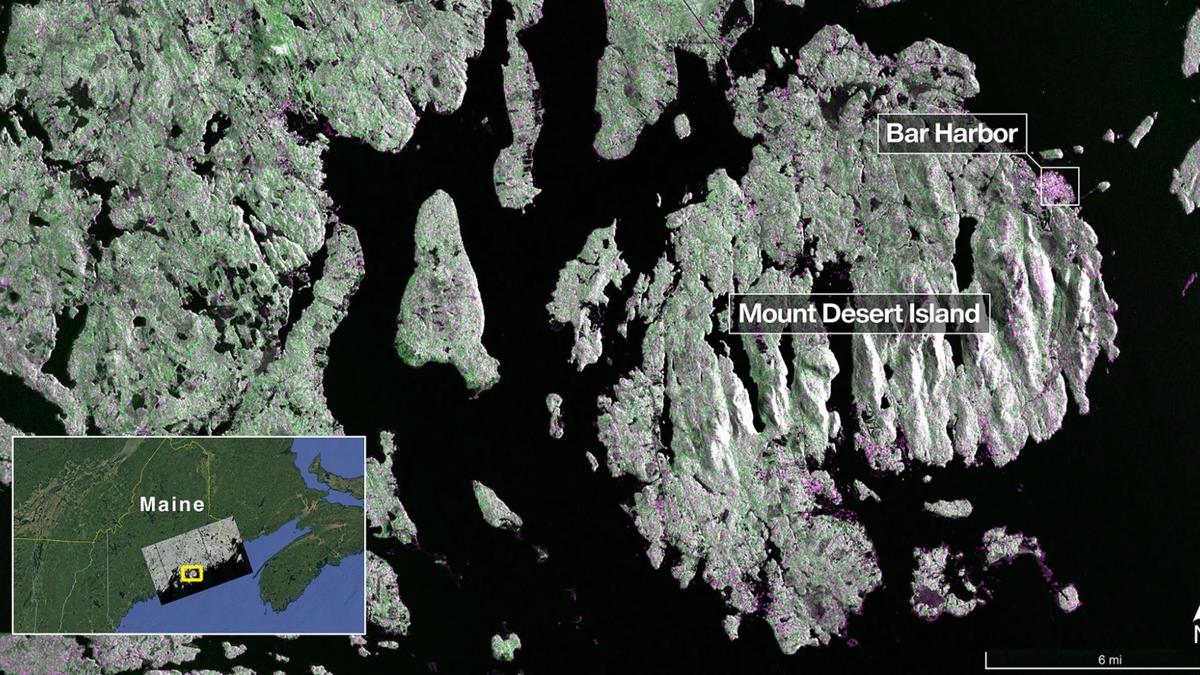
Captured on August 21, this image from NISAR’s L-band radar shows Maine’s Mount Desert Island. Green indicates forest, while magenta represents hard or regular surfaces, such as bare ground and buildings. The magenta area on the island’s northeast end is the town of Bar Harbor. Photo: Special Arrangement

Captured on August 21, this image from NISAR’s L-band radar shows Maine’s Mount Desert Island. Green indicates forest, while magenta represents hard or regular surfaces, such as bare ground and buildings. The magenta area on the island’s northeast end is the town of Bar Harbor. Photo: Special Arrangement

The NASA-ISRO Synthetic Aperture Radar (NISAR) Earth-observing radar satellite has sent the first images of Earth’s surface as the joint mission between NASA and ISRO approaches full science operations later this year.

NASA said that the images from the spacecraft, which was launched by ISRO on July 30, display the level of detail with which NISAR scans Earth to provide unique, actionable information to decision-makers in a diverse range of areas, including disaster response, infrastructure monitoring, and agricultural management.

“By understanding how our home planet works, we can produce models and analysis of how other planets in our solar system and beyond work as we prepare to send humanity on an epic journey back to the Moon and onward to Mars,” said NASA Associate Administrator Amit Kshatriya.

Fruits of collaboration

He added that the successful capture of these first images from NISAR is a remarkable example of how partnership and collaboration between two nations, on opposite sides of the world, can achieve great things together for the benefit of all.

NASA said that on August 21, the satellite’s L-band synthetic aperture radar (SAR) system, which was provided by NASA’s Jet Propulsion Laboratory in Southern California, captured Mount Desert Island on the Maine coast.

“Dark areas represent water, while green areas are forest, and magenta areas are hard or regular surfaces, such as bare ground and buildings. The L-band radar system can resolve objects as small as 15 feet (five metres), enabling the image to display narrow waterways cutting across the island, as well as the islets dotting the waters around it,” NASA said.

It added that on August 23, the L-band SAR captured data of a portion of northeastern North Dakota straddling Grand Forks and Walsh counties.

“The image shows forests and wetlands on the banks of the Forest River passing through the centre of the frame from west to east and farmland to the north and south. The dark agricultural plots show fallow fields, while the lighter colors represent the presence of pasture or crops, such as soybean and corn. Circular patterns indicate the use of centre-pivot irrigation,” it added.

The U.S. space agency further said that the images demonstrate how the L-band SAR can discern what type of land cover — low-lying vegetation, trees, and human structures — is present in each area.

Gain and loss of forests

“This capability is vital both for monitoring the gain and loss of forest and wetland ecosystems, as well as for tracking the progress of crops through growing seasons around the world,” it said.

Published – September 27, 2025 12:02 am IST


Source link

NewsClick founder Prabir Purkayastha’s arrest invalid, says Supreme Court
Efforts are on to expand our products base, says CPCL MD
The Hindu journalist wins award
Tamil Nadu Assembly | Self-certification limit for residential building approvals raised to 5,000 sq. ft.: Housing Minister
Cyberabad Police arrest Vizag man for posting abusive comment against actress Renu Desai on Instagram
TAGGED:Bengalurufirst radar images of earth’s surfaceISROkarnatakaNASANASA-ISRO Synthetic Aperture Radar (NISAR) Earth-observing radar satelliteNISAR
Share This Article
Facebook Email Print
Leave a Comment

Leave a Reply Cancel reply

Your email address will not be published. Required fields are marked *

Follow US

Find US on Social Medias
FacebookLike
XFollow
YoutubeSubscribe
TelegramFollow

Weekly Newsletter

Subscribe to our newsletter to get our newest articles instantly!
[mc4wp_form]
Popular News

Nurses lay siege to DLO’s office in Kannur

India Times Now Desk
June 23, 2026
How U.S.-Israel attack on Iran could impact millions of Indian migrant workers
Dead-drop drug raid turns chaotic as brothers unleash dogs, stab cop and flee across rooftops
IAF successfully conducts trial of Indigenous Long-Range Glide Bomb Khagantak-243
Revenue-deficit States may face fiscal stress, says Centre
- Advertisement -
Ad imageAd image
Global Coronavirus Cases

Confirmed

0

Death

0

More Information:Covid-19 Statistics
© INDIA TIMES NOW 2026 . All Rights Reserved.
Welcome Back!

Sign in to your account

Username or Email Address
Password

Lost your password?